History of Hancock (1888-1998)
CENTENNIAL SOUVENIR BOOKLET
Sponsored by: Hancock-Chehocton Historical Association
Dedication: The Hancock-Chehocton Historical Association dedicates this booklet to the memory of the late Lucile Howell. She was a dedicated village historian. Her interest in and knowledge of the history of Hancock was the guiding factor in the formation of the association. Lucile Howell 1907-1985
Centennial Booklet Committee
Chairperson: PatriciaGreen
Researchers: Muriel Biggs Georgena Bouchoux Jack Casey Doris Chamberlain Adrienne Crosby Doris Davis Edith Mackin
Cover: 1850 Hand sketch by William Macleod. Wooden rail-road bridge can be seen to far right. House on left probably that of Charles Leonard, Sr.
This was digitized by Richard Lowe and there may be formatting or spelling issues, as we used AI-Technology to scan, detect and make this copy of the booklet available in a digital format to share online. We apologize for any mistakes and issues and encourage edits. Please email us any corrections to: Email the Chamber of Commerce or comment below the article. This will be added to over the coming weeks 5-pages at a time.
BOOK BEGINS


Hancock was known as Chehocton until after the Erie Railroad went through in I 848. Though the spelling went through various stages Chehocton and Shehawken seem to have been the most common. It appears that the lands encompassed by the present village were once owned by Benjamin Sands, Samuel Sands, John Dusenbury, and Ezra May.
The relationship of Benjamin, Henry and Samuel Sands has not been determined, but they and Samuel’s brother-in-law, Dusenbury, earlier settled Partridge Island on the East Branch of the Delaware River before moving to the West Branch and starting settlement in that area. Samuel Sands owned the major part of now “West End” including hundreds of acres beyond the village limits. Ezra May owned the rest of the village and part of Cadosia. He sold land to Daniel Broadstreet (1820), Charles Leonard (1817), and John Hawk, Jr. (1822), the earliest settlers of the village.
We present a wilderness developing into the Village of Hancock. We will start our journey at the west end of the village. One Benjamin Sands was to have come to Chehocton in 1792 purchasing 3000 acres from the foot of Catholic Church Hill westerly. He built the first sawmill at the lower end of Sands Creek where the O & W Railroad later crossed. He also built the first plank house opposite the sawmill. This area is now the location of the Route 17 overpass at Exit 87. Further downstream at the present location of Kaplan’s Chevy-Buick, William Hall and Thomas Crary built a gristmill known as Hancock Mills in 1883. Various additions made a very large mill and the Erie built a spur into the mill for loading and unloading grain directly to and from the bins. The mill had a capacity of 40 rail cars. It was twice struck by fire in 1891 and 1899. When they rebuilt in 1891 they converted from water-power to steam. A 36-inch snowfall hindered firemen from saving the mill in 1899. Hall bought out Crary and rented the first floor of the E.W. Griffis store, the present Masonic Hall.
Following West Main Street easterly, we come to the location of Larimer Norton Wood Products. This area, including the lane immediately easterly and along the river, was the fann of Samuel Sands. In 1880, the New York Transit Co. built a pumping station on this site. Huge cylinders of iron tubing were laid underground from the oil region to Catatonk on the D.L. & W. Railroad, 75 miles to Hancock on the Erie road and eventually east to Otisville, a terminus of a branch line. It was expected to force oil here from Oswego without any intervening pumping station. Once the tanks were constructed crude oil was pumped to Hancock then loaded on railroad cars for shipment to areas of processing. It was very expensive to ship crude oil over rail, thus the idea of the pipeline was conceived. In January 1881, the average shipment was 62 cars a day; the most being 82. In April 1881, the rest of the line was finished and the large pump was started to pump the crude oil on toward Otisville.
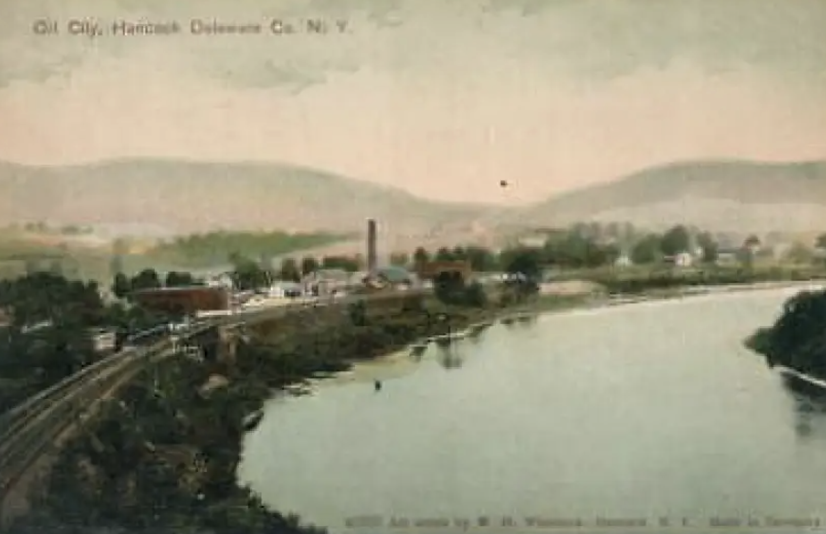
The landmark smokestack can be seen in .the picture of “Oil City” as “West End” was known on into the early 1900s. The pipelines were abandoned in the 1920s and Columbia Gas & Electric Co. took over the lines in 1929 to furnish the village with natural gas. However, they did not purchase the local property. In 1934, E.S. “Nide” Ramburg and D.F. Carr purchased the property from Standard Oil and so began baseball bat production in Hancock. Mr. Ramburg became sole owner in 1935. The business was reorganized in 1959 as Ramburg Wood Products. In 1966, holdings were sold to Larimer and Norton, marketers of the Louisville Slugger.
Approaching the comer of West Front Street Extension and West Main we must use our imagination to visualize a time when most of this area was unpopulated. From 1815 to 1820 general trainings of the “Oil City” were held each fall on the flats to the north of Main Street. Militia came from all over the county to participate. These trainings were held someplace in the county each year up until the Civil War. By the late 1800s there was a large farm in this section. In 1887, it was owned by E. w. Griffis who moved a house from the lot between the Masonic Building and the former Hancock House to this site to have a new house constructed at the downtown site. He also had a large addition to the barn and a “new fashioned hennery” built.
Making our way up Church Hill we can note some early houses as we pass by. The Collarini house, to the right can be noted to be two houses put together. Mr. Fred Whitaker, Sr. once noted that one of these was part of a Sands house. Two doors up is another early home. Looking across this block toward Front Street we see the top of a house situated beyond the railroad tracks. This property, when sold to James Munsell (Hancock) and Grover Buell (Windsor) in 1828 by Samuel and Artemisa Sands, was described in the deed as a parcel “occupied and possessed as part of the farm where Sands now lives, being a part of the farm conveyed by Philip Livingston to Henry Sands and John Dusenbury May 1804.” James Munsell built the long-dwelling house and used it as a store. It was later used by Marvin Wheeler and then Allison and Reeve Wheeler signed off a right-of-way to the New York Erie Railroad in 1836 and stipulated a crossing be made in front of his store to W. Front Street.
This was pursued in 1958 by Frank Cappiello, but it never came to be. The house, which partially stood on the right-of-way, was moved southerly two feet from the right-of-way ‘in 1921. This property was bordered northerly by the western end of the road from the East to the West (Branch of the Delaware River). The road led to the river and a fording to the Pennsylvania side. This was the major fording to Newton’s Store, the first in the area. The road from the East to the West proceeded easterly along present Front Street with various fording areas on the East Branch of the Delaware. About 1851-52, this road became the first hard surfaced road in this part of the county. Known then as the Delaware Plank Road, it was surfaced with three-inch hemlock planks and was twelve feet wide. it was a toll road that connected Hancock to Delhi. With the presence of the Erie Railroad and the building of the Plank Road, Hancock became a major shipping point and began to grow. The Plank Road continued successfully until the Midland Railroad in 1873 connected points easterly to the northern part of the county.
Teamsters made up songs voicing their resentment at the loss of livelihood due to the railroad: “May the devil take the man, that invented such a plan. It will ruin us poor wagoners and every other man.” The section of the road from Cotter’s Comer (E. Front & Read Streets) easterly to Cadosia later became part of the Liberty Highway or Route 17, a new road from the East to the West connecting New York City to the western part of the state. When .the current Route 17 Expressway bypassed the village, this section became part of Route 97 but is better known simply as East Front Street.
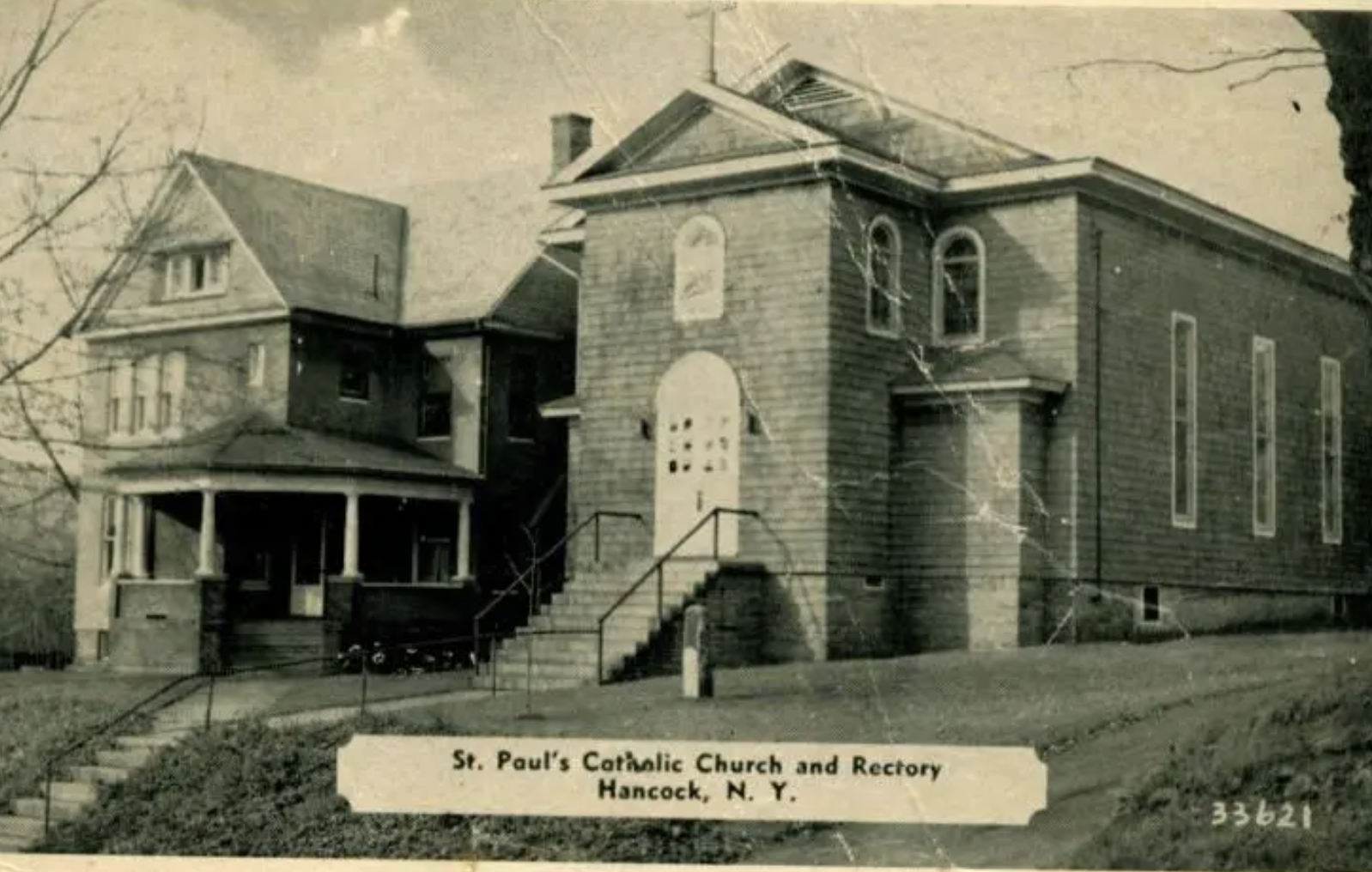
Now let us return our attention to West Main Street. As we near the top of the hill we see St. Paul’s Catholic Church situated on the north side of the street. The Catholic Church was organized in 1851 and was pastored from Deposit for many years. The Catholics are said to have used the Broadstreet house, presumably during the church’s early years before any edifice was built. The first edifice was built in 1869- 70 and dedicated June 12, 1870. This building was destroyed in 1883 when a cyclone swept through the village and it was lifted from its foundation and hurled in a heap in the yard next door. The building and furnishings had cost $7000. A small parlor organ was the only thing salvaged. The people went about raising funds to erect a new edifice similar to the former except with no high spire but instead, a belfry. This, the present structure, was erected in 1884-85. Extensive interior renovations were made in 1895. St. Paul’s Parish Hall, now Father Rausch Memorial, was dedicated in 1954
Approaching the comer of West Main and Pennsylvania Avenue we overlook various historic sites. On the northwest comer is a large home once owned by Marvin Wheeler. This building is shown on the 1856 map St. Paul’s Catholic Church as belonging to Elisha Richards and probably was later added on to. On the northeast corner we have the home formerly owned by Mrs. Ethel Clark. This Victorian home either replaced a previous one or the former was moved over. The present house next door is obviously of an earlier time and though re-sided has retained the front style.
In 1890, the Scranton Branch of the O& W Railroad was built to connect with the former Midland Railroad east of the village. The depot was situated at the end of Railroad Avenue , now Pennsylvania Avenue.
